AirGuard
- Save time on course monitoring
- Detect early signs of stress or disease
- Optimise the use of resources
Thank you for your interest in AirGuard. By completing the form, you can request a tailored quote based on your course and specific requirements. Share your details and our specialists will review your situation and get in touch to discuss the right configuration for your golf course.
"*" indicates required fields
AirGuard is an integrated drone-based monitoring system that gives golf course managers a complete, data-driven view of turf health and course performance. The system combines high-quality aerial data capture with a powerful analytics dashboard, enabling smarter decisions across the entire course. By uniting drone technology and advanced software in one structured workflow, AirGuard supports more efficient maintenance, higher playing quality, and greater control throughout the season.
At the heart of AirGuard is TurfBase Golf, the data dashboard that transforms raw aerial data into clear, actionable insights. Together, the drone and TurfBase Golf form one coherent system designed to support next-level professional turf management.
How it works
AirGuard turns aerial data into clear, actionable insights through a simple and structured process.
- Capture data
A drone flight captures high-resolution aerial imagery of the course, including RGB, multispectral, and thermal data. These flights form the data foundation of the AirGuard system. - Process and analyse
The captured imagery is uploaded to TurfBase Golf, where it is automatically processed into accurate, geo-referenced turf health maps. - Review and act
Insights are available shortly after processing. TurfBase Golf allows you to analyse results, compare flights over time, and identify priorities for targeted maintenance.
The result is a clear, course-wide overview that supports faster, smarter, and more efficient turf management decisions.


TurfBase Golf: the data brain of your course
TurfBase Golf is the data and analytics dashboard within the AirGuard system, designed to translate aerial imagery into clear, practical insights for golf course management. It transforms complex drone data into an accessible overview of turf health and performance trends across the course. By combining automated processing with intuitive visualisation, TurfBase Golf supports confident, data-driven decisions without adding complexity to daily operations.
The platform enables greenkeepers, supertintendents and course managers to identify priorities, monitor changes over time, and evaluate the impact of maintenance actions. As the analytical core of AirGuard, TurfBase Golf brings structure, clarity, and consistency to modern, professional turf management.
Advanced turf health analytics
AirGuard transforms multispectral data into actionable knowledge, analysing NDVI, NDRE, and Chlorophyll Index to reveal the hidden patterns of your greens, fairways, and tees, so you always know exactly what your turf needs.
-
- NDVI: Shows overall turf health and density by comparing how much red vs. near-infrared light the grass reflects.
- NDRE: Detects early stress and chlorophyll levels using the red edge spectrum, catching issues before they’re visible.
- Cholorphyll Index: Measures the actual chlorophyll in leaves, showing how green, healthy, and photosynthetically active the turf is.

Smart hot spot detection
Powerful algorithms highlight the areas that truly matter, while TurfBase Golf’s turf-optimized map colors automatically bring every stress pattern to life, making insights immediately clear without any manual setup.
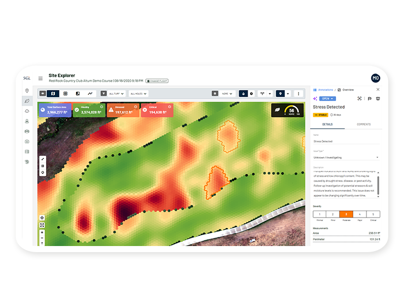
Track, compare & improve
See your course evolve over time. With interactive reports, historical comparisons, and visual trend tracking, TurfBase Golf lets you measure the impact of treatments, experiment confidently, and celebrate visible progress.

Next-level course control
From on-screen measurements to mobile-ready reports, TurfBase Golf empowers you to plan, prioritise, and act anywhere on the course, turning data into decisions and decisions into exceptional turf quality.


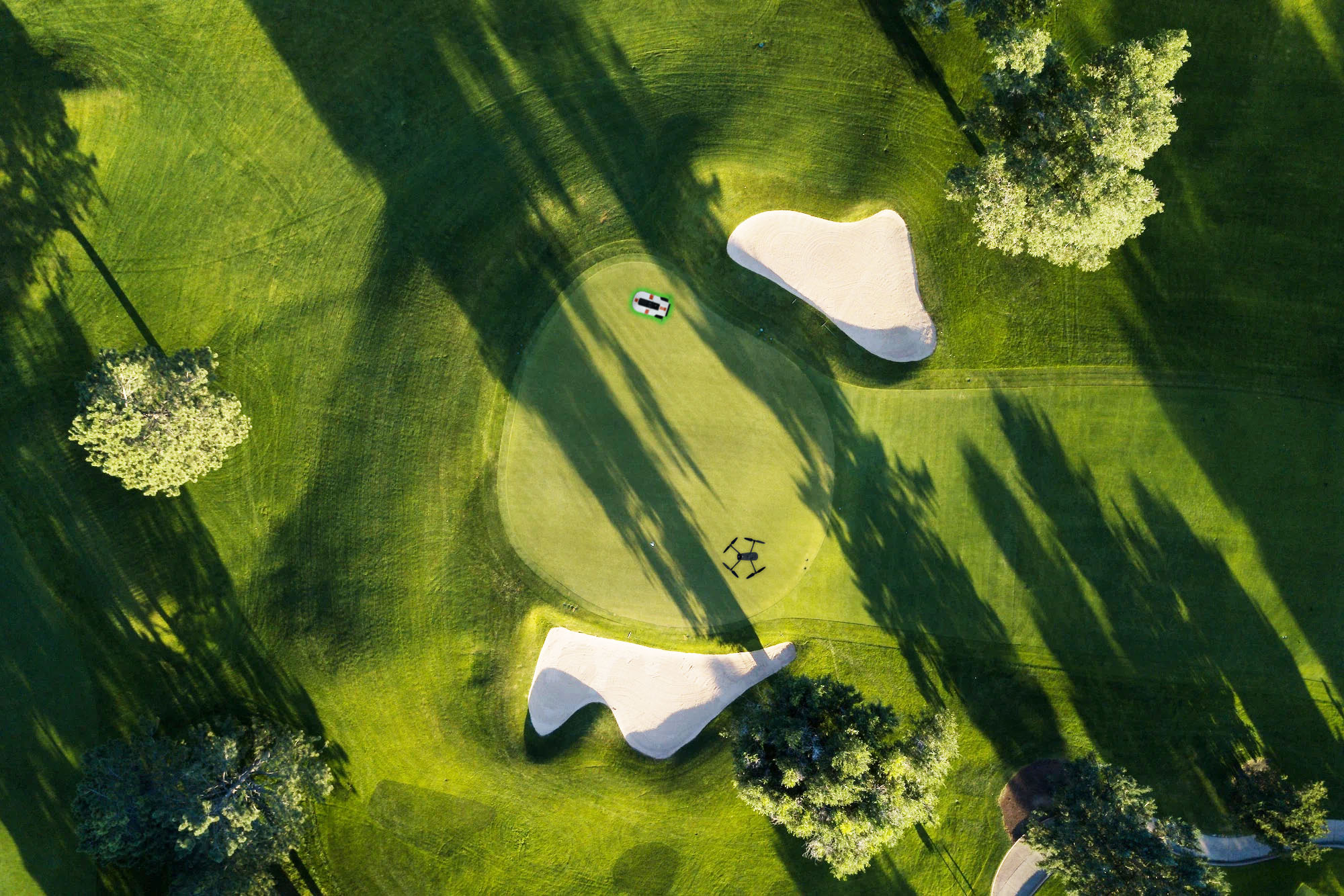
DJI Mavic 3M: the eyes of your course
AirGuard is recommended with the DJI Mavic 3M, a professional multispectral drone that plays a central role in the system’s data capture. Acting as the eyes of AirGuard, the Mavic 3M collects high-resolution aerial data that feeds directly into TurfBase Golf.
Its 20 MP RGB camera and four 5 MP multispectral sensors capture detailed information across green, red, red-edge, and near-infrared wavelengths, revealing turf conditions and subtle variations that are not visible from the ground. This data enables TurfBase Golf to deliver accurate stress detection, moisture mapping, and course-wide insights.
With centimetre-level RTK positioning, omnidirectional obstacle sensing, and long flight endurance, the Mavic 3M ensures precise, safe, and efficient coverage as part of the complete AirGuard system.
FAQ
Drone flights can be carried out by course’s staff or external pilots. A licensed drone pilot is required in line with local aviation regulations. If preferred, flights can also be performed by professional drone service providers.
Yes, AirGuard can be delivered with a recommended drone. The DJI Mavic 3M is a proven option that meets the requirements for accurate data collection and reliable execution of AirGuard flights.
Yes, AirGuard supports a wide range of multispectral and precision agricultural cameras. As long as your drone and camera meet the data requirements, they can be used with the platform.
This depends on course size, seasonal conditions, and management objectives. Many courses fly regularly during the growing season, but AirGuard itself does not require a fixed flight frequency.
No, AirGuard is designed to be user-centred and mobile friendly. Data processing is fully automated, and insights are presented in clear maps, dashboards, and reports.
Yes, AirGuard supports multi-user access, allowing teams to collaborate using the same data set.
Yes, AirGuard reports and insights can be shared, making it easy to communicate course conditions and decisions with boards, owners, and external consultants.
Download our brochure
"*" indicates required fields